Determining a Lunar landing Site
トピックアウトライン
-
Author: Peter Higgins, PhD
Keywords: Apollo, landing site, lunar landing, surveyor, lunar orbiter, lunar photography, Schumacher, Dornbach
Intended for students 14+
Prerequisites: some basic science, mostly history, no mathematics
Articles in NASA's weekly published "Space News" Roundup in the 1960's which was distributed to all employees of the Manned Spacecraft Center (now renamed Johnson Space Center) in Houston, Texas, chronicle the story of how a location for the Apollo lunar landing was determined by the evaluation of possible sites. This was largely accomplished by the unmanned spacecrafts Surveyor and Lunar Orbiter, and by photography taken on Apollo 8. This lesson tracks these articles.
Site selection crteria
The following has been given on site selection criteria:
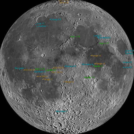
On February 8, 1968, after two years of study NASA’s Apollo Site Selection Board announced five potential landing sites for the first human lunar landing. Each of the five 3 by 5-mile landing areas, chosen from an original list of 30 candidate sites, satisfied certain criteria in which astronaut safety was paramount. All five sites were within the Apollo Zone of Interest, an area on the visible side of the Moon between 45 degrees East and West longitude and between 5 degrees North and South of the lunar equator. The sites were centered around the following coordinates:
- Site One: 34o East, 2o40” North, in the Sea of Tranquility (Mare Tranquilitatis);
- Site Two: 23o37” East, 0o45” North, in the Sea of Tranquility (Mare Tranquilitatis);
- Site Three: 1o20” West, 0o25” North, in the Central Bay (Sinus Medii);
- Site Four: 36o25” West, 3o30” South, in the Ocean of Storms (Oceanus Procellarum);
- Site Five: 41o40” West, 1o40” North, in the Ocean of Storms (Oceanus Procellarum).
To select the five areas, the Board used high-resolution orbital photography returned by five Lunar Orbiters and surface data and photographs provided by Surveyors that landed in the general area of some of the sites. The Board considered the following criteria to determine the suitability of the candidate sites:
- Smoothness of the area: the sites should have relatively few craters;
- Approach paths: there should be no large hills, tall cliffs or deep craters which could cause incorrect altitude signals to the landing radar;
- Propellant: the sites were selected to allow for the expenditure of the least amount of propellant;
- Recycling during countdown: the sites were selected to allow for the recycling time of the Saturn 5 if the countdown were to be delayed;
- Free-return: the sites must be within reach of the Apollo spacecraft in the free-return trajectory, that is a path that would allow a coast around the Moon and safe return to Earth without any engine firings should a problem arise on the way to the Moon;
- Lighting: for optimum visibility during the landing approach, the Sun angle should be between 7 and 20 degrees behind the LM; for any given site, this results in a one-day launch window per month;
- Slope: the general slope of the landing area must be less than 2 degrees.
The site selection board members were:
MA/Gen. S. C. Phillips MA/Dr. J. H. Turnock MO/Gen. J. D. Stevenson ML/Mr. C. W. Mathews SO/Mr. O. W. Nicks MSC-PD/Mr. O. E. Maynard MSC-TA/Dr. W. N. Hess MSFC-R-RP/Dr. E. Stuhlinger . KSC-AP/Adm. R. O. Middleton
-
My interest in this topic is the consequence of an early association with it. In 1962 the Apollo Spacecraft Project Office was created and led by Calvin H. Perrine. This consisted of a group of about 20 NASA aerospace technologists having responsibility for evaluating contract proposals from the various aerospace vendors, such as North American, and Grumman. The proposal evaluations were done to select the best contractors to design and build the Apollo command module, the Lunar Lander and the Apollo Service module. Each member of this team was assigned to evaluate a particular subject, such as communication; I was on this team, and was assigned the topic space environment. Space environment included three components: lunar surface composition, micrometeorite flux and penetration, and space radiation. The contractor's understanding of lunar surface composition would be apparent in their design of the legs and foot pads of their proposed lunar lander. Specifically, each contractor would have to have made assumptions on the bearing strength of the lunar surface and on the depth of the dust (fine particle) layer the lander would encounter as it descended. Bearing strength and the dust environment was a major unknown to be resolved. To resolve them NASA would send probes to the moon and develop high resolution photography. The probe vehicles were the Surveyor and Lunar Orbiter spacecraft.
I left the project office being assigned to work on the radiation component in the Space Environment division - radiation branch. There were two other branches in that division - one to work on meteorite flux and penetration, the other to deal with lunar mapping and photography. The lunar mapping branch was headed by John Dornbach who would be influential in advising on site selection, as mentioned later, while the division was lead by Jack Eggleston. Jack Eggleston, while not a board member of the selection committee, was very active in its runnng and organizatiion. Wilmont Hess, was a board member, who later headed Space Physics where I was Section Head of Radiation Analysis, and eventually became director of NOAA where he would fund my Master's project of an acoustic doppler wake turbulence system for Denver's Stapleton Airport (its previous airport).
-
Probe landing sites
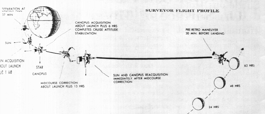
Surveyor 1, Roundup, Jun 10, 1966, "Surveyor Soft-Lands On Surface of Moon"
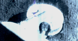
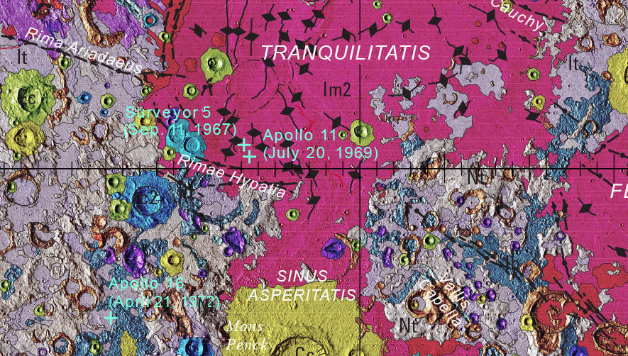
The first Surveyor spacecraft landed June 2, 1966 2.49 degrees South of the lunar equator, at a longitude of 43.32 W. These coordinates place the landing in the Sea of Storms North of the crater Flamsteed. This location was chosen because it was a potential Apollo landing site. As it happens, Apollo 11 landed near this latitude but much farther East as is indicated on the image on the right. The legs of the lander were instrumented with strain gauges to record impact stress. Additionally it had both low and high resolution TV cameras on-board.
The on-board TV camera sent back a very important image of the indentation of the lunar surface made on impact by the lander's foot. The image shows the indentation to be slight indicating good bearing strength absent of a significant dust layer, the latter being substantiated by an absence of dust on the visible surfaces.The mission of the first surveyor was significant in other ways which included:
- Capability of a launch vehicle (Atlas/Centaur) to inject a spacecraft into a lunar intercept trajectory.
- To perform midcourse and terminal maneuvers necessary for a soft landing, and
- Demonstrate the capabiliy of its communications system, and of the Deep Space Network to maintain communications with it during and after landing.
These accomplishments would be crucial to the docking maneuvers need in conrad's Gemini 11 flight that required docking with the Agena vehicle in order to boost into an eliptical orbit placing Gemini 11 high over Australia just a few months later.
Surveyor B Launching Scheduled for Tuesday, Roundup, September 16, 1966
NASA continued its program of scouting potential Apollo landing sites with the launch of a sister spacecraft beginning September 20, 1966. Based on photographs taken by the first Lunar Orbiter, Surveyor B was targeted to Sinus Medii near the center of the moon. Unlike the nearly vertical descent of Surveyor 1, Surveyor B will approach at an angle of 23 degrees which demonstrates the ability of the spacecraft to soft-land in the eastern quadrant of the moon.
Surveyor V Answers Many Lunar Questions, Roundup, October 13, 1967
The article states:
"Photographs of the surface immediately under the rocket nozzles indicate that no craters were made on the moon and no appreciable dust cloud was created by the exhaust."
-
Lunar Orbiter Scouts Apollo Landing Zones, Roundup August 19, 1966.
The first launch of the lunar orbiter was on August 10, 1966. Its mission was to photograph nine potential Apollo landing sites shown as gray rectangles in the figure below. The vehicle, also below, was an open-truss structure measuring 18.5 feet across with its antennas deployed and stood 5.5 feet high. It weighed 850 pounds, and was equipped with a camera having both medium and high resolution lenses. At an altitude of 28 miles above the surface, photos with the high resolution lens covered 20 square miles extending to 350 square miles with the medium resolution lens.
lunar orbiter 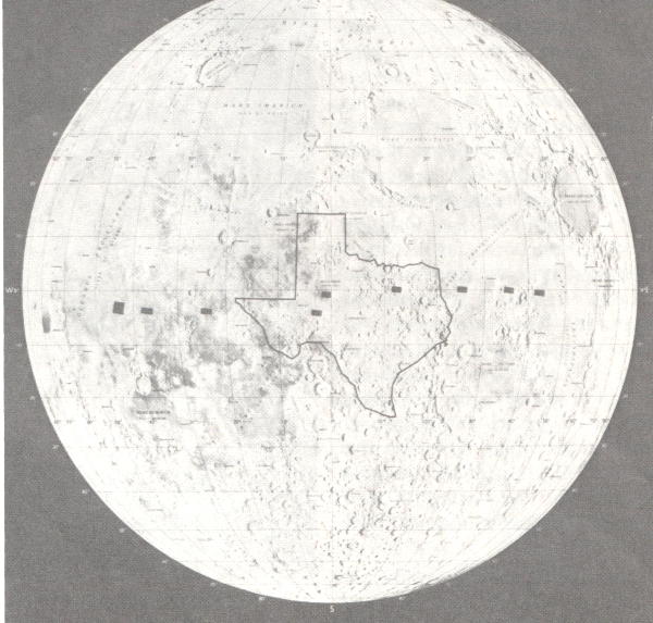

-
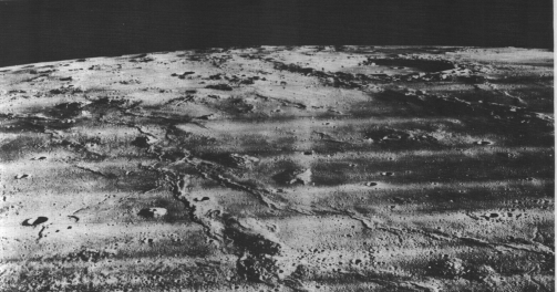
Lunar Orbiter 2 Photographs
Image made with medium range lens shows domes 2 to 10 miles in diameter and 1000 to 1500 feet high.
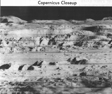
Lunar Orbiter's 2 telephoto lens made this low angle image across the crater Copernicus. Cliffs on the rim of the crater are 1000 feet high;
L
Apollo 8 photography of Apollo landing site 1
Apollo 8 encircled the moon in late December 1968. Photographing potential Apollo landing sites was a secondary mission objective. The crew photographed the surface with Hasselblad cameras which produced beautiful images like:
About this Lovell said:
"the Lunar Orbiter photographs which we had on board were quite adequate. There was no problem at all in determining objects particularly on the near side of the moon. There are suitable landing-sites. They are very easily distinguished. We could pick them up. We could work our way in. . . . The Lunar Orbiter photos again were helpful . . . to check the craters on the back side.) "
NASA TECHNICAL MEMORANDUM, APOLLO LUNAR LANDING MISSION SYMPOSIUM JUNE 25-27, 1966 Manned Spacecraft Center Houston, Texas NASA-TM-X-58006)
LUNAR LANDING SITE DATA SOURCES AND ANALYSIS By John E. Dornbach, Chief, Lunar Surface Technology Branch, Instrumentation and Electronic Systems Division, NASA Manned Spacecraft Center
Earth studies and mapsAt the present time most of the visible face of the Moon has been mapped for the NASA by the u.s. Air Force Aeronautical Chart and Information Center . These charts at sixteen miles to the inch are about the same scale as the best you could get today for covering parts of Antarctica, Australia, and Africa . By carefully measuring on observatory photographs, the lengths of shadow s cast by craters at low sun angles , we are able to estimate one thousand foot contours on the lunar surface. This slide illustrates that at this scale charts of the lunar equatorial region, or the region of interest for early Apollo missions , have already been completed . The area covered by one of these chart s is shown by the outline of the Kepler chart .
Contrbution made by Kuiper
FIGURE 13 - KUIPER BEARING STRENGTH ANALYSISBy formulating concepts for the evolution and morphology of features seen on the Ranger photographs, it is possible to estimate some physical properties . Dr. Gerard Kuiper of the University of Arizona and Principal Investigator for Ranger photography established several basic assumptions and from them, estimated the bearing strength of the cratered surface. He examined many protuberances , indicated on this Ranger IX photograph by small arrows, and surmised that they were materials ejected from the 150 ft. primary crater at the top of the photo . The materials measured at the 10° sun angle appeared to be about 3 feet across and about a foot high . Assuming they were ejected from the primary crater to where they are found and that their bulk density was about 2, he concluded that most of the protuberances were probably half squashed and half buried . From this he concluded the bearing strength to be over 14 pounds per square inch averaged for the upper one to two feet of this part of the lunar surface.
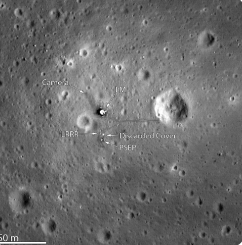
A photograph of the Apollo 11 landing site showing descent stage left behind
Photo taken at 24 km altitude by NASA's Lunar Reconnaissance Orbiter after the landing.
-
Dr. Schumacher Speaks to AIAA, Roundup, December 9, 1966
 Dr. Eugene M. Schumacher, chief scientist with the US Geological Survey Observatory at Flagstaff, Arizona gave a talk in Houston on the new data from the Surveyor and Lunar Orbiter spacecraft. He is particularly impressed by the clean surfaces in the photographs making good observations by astronauts of fine structure possible.
Ames Scientists Develop Method To Calculate Lunar Surface Soil Depths, Roundup, April 12, 1968
By now the criteria for site selection has progressed from concerns about mission success and astronaut safety, to the science of lunar geology. Working with photographs from the Surveyor and the Lunar Orbiters spacecraft, NASA Ames Scientists have developed methods of calculating lunar soil depths in most landing locations. The article says, " this will aid in selection of the sites from which future crewmen will select rock samples"
Dr. John E Dornbach
 When I was transferred to the Space Environment Division, a part of the Advanced Spacecraft Technology Directorate under Max Faget, and headed then by jack Eggleston, John Dornback was the lunar mapping expert and head of a branch in this division responsible for the lunar environment. He would be a lead player in the 1966 conference on the lunar surface discussed above, and was instrumental in the topology aspects of selecting an Apollo landing site.
 -
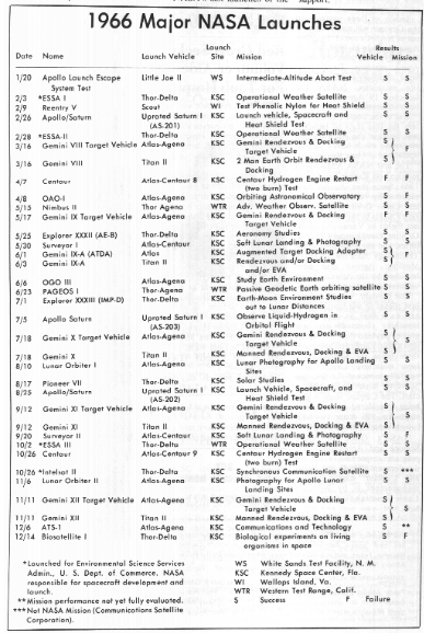
Launch Schedule, Roundup, January 20, 1967
-
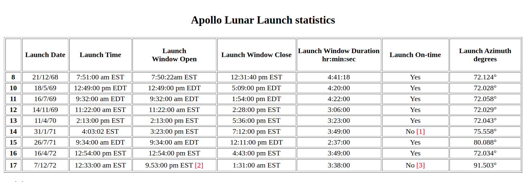
Lunar topology was a consideration in selecting the Apollo landing sites as most would suppose: you wouldn't try to land in a boulder field or on the steep slope of a crater. Such sites could be easily eliminated by good lunar maps, photographs made from large telescopes or from orbiting spacecraft or landers. What is not so apparent is that availability of good sites is restricted by launch location, time of launch, and booster performance. Such limitations are become launch windows, and access to a particular lunar site in latitude and longitude is constrained by these windows. For example the following graphic shows the effect of launch windows on where on the moon you want to go (zones of accessibility are outlined):

The Apollo launch windows are tabulated below:
As mentioned earlier, the US Geological Survey Science Center, represented by Dr. Schumacher, figured prominently in lunar mapping that met NASA's needs in associating lunar topological features (geology) with lunar position as evident in their lunar maps such as:
In summary we learn that NASA relied on its own resources to pick the Apollo landing sites proceeding with:
- establishing criteria for acceptable landing sites by an advisory commission,
- working through the orbital mechanics for a Cape Kennedy launch for best lunar insertion, free return, and favorable lighting conditions for descent,
- sending Surveyor and lunar Orbiter to photograph the list of possible site determined from the above,
- coordination with US Geological Survey experts to support its science objectives which centered on appropriate rock gathering by astronauts
- confirming its final choice by Apollo 8 photography
-
Next Generation Science Standards:NGSS:HS-ESS1-4 Earth's Place in the UniverseHS-ESS3-4 Earth and Human ActivityHS-ESS1-4 Engineering DesignHS-PS-3 EnergyCommon Core Sate Standards:CCSS:ELA-LIteracy.RH9-10.7; 10.8; and 10.10
-
Send a Postcard to Space through NSS Supported Blue Origin Club For The Future initiative!
Visit: SpacEdge Academy Postcards in Space Course